
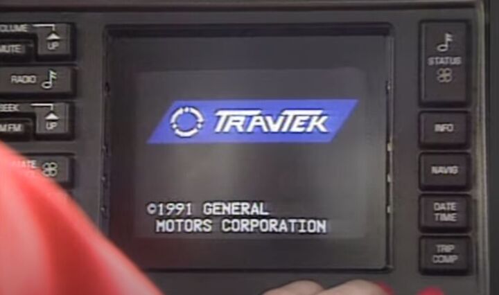
We return to our spicy Oldsmobile content this week, with the introduction of GM’s first publicly tested in-car navigation system, TravTek. Arriving in the early Nineties, TravTek was launched more than two decades after GM’s magnet-based DAIR prototype failed to make production. This time The General was determined to make good on their big investment. Onward, to Orlando!
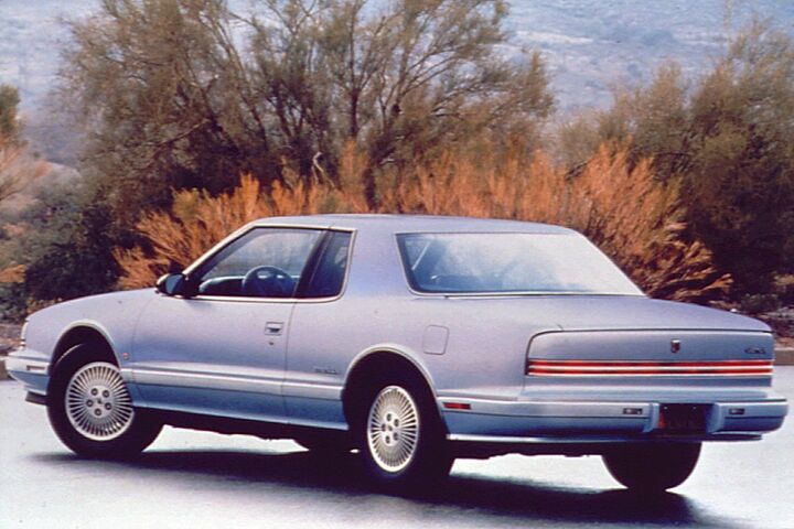
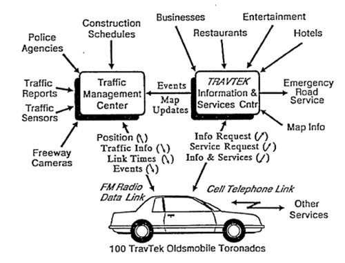
As detailed in the last installment, the new TravTek system was installed in 100 total 1992 Oldsmobile Toronados in Troféo trim. Of those, 75 would be rented through Avis via its Orlando International Airport location. The remaining 25 were leased to local drivers who spent lots of time cruising the greater Orlando area. In addition to distribution through Avis, Florida’s DoT was part of the project, along with AAA.
The overall objective of the soft launch of TravTek in Orlando was to explore the feasibility of an Advanced Driver Information System (ADIS), and whether regular drivers would accept such technology in a car. A quaint consideration in 2023 certainly, in the era of the widescreen 4K dashboard. The DoT was interested to see if the system would increase safety and use of the highways, as well as its potential to reduce travel time via traffic information, which would lead to lower fuel consumption.
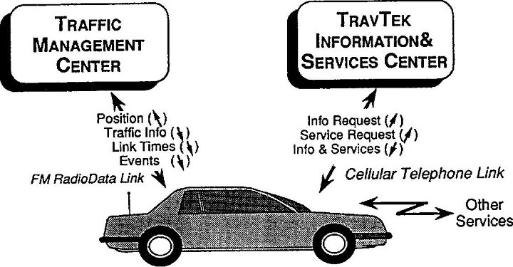
General Motors maintained responsibility for the base system in the Toronados that provided the guidance and travel information. The Federal Highway Administration worked in conjunction with the Florida DoT and the city of Orlando to establish a new Traffic Management Center (TMC) in Orlando. The TMC gathered information on local traffic conditions from various government sources, as well as the Toronados themselves. Aggregated, the traffic information was then eventually passed back to TravTek to help users avoid congestion while driving.

The final piece of support came from AAA, which launched the TravTek Information and Services Center, or TISC. The TISC was the hub for the daily operations of TravTek. The office assisted users and provided Orlando-specific information at the request of TravTek users. The aforementioned data from government sources also passed through AAA’s hands before being sent back to TravTek.
Information was sourced from highway cameras, traffic signals, construction reports, and emergency vehicles in the area. This formed one of the key features of TravTek, way ahead of its time: Live traffic information and route revision. All information was displayed on the central 6-inch touchscreen in the Toronado.
Routes were displayed via a purple line across the map that was constant and showed the start and end points of the guidance. The Toronado was represented by a white arrow, which moved along the purple line as the route continued. Also provided were distance to destination details and time estimates.
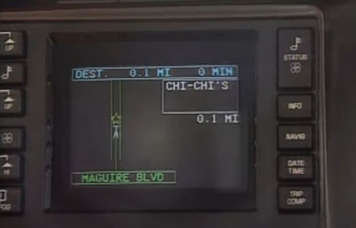
Joining the car on the route map were small red stars that indicated accidents. Heavy, stopped traffic appeared via a yellow circle. And a similar-looking red circle meant a road was closed. Should a wrong turn be made, there was no automatic rerouting on the fly. A driver could choose between two fixes. The first was a New Route button that would set up a new starting point from the car’s current location, and reroute from there.
Since it was a brand-new technology, AAA felt that more drivers might choose to call for help. The Help button on the map screen made an immediate phone call to the TISC. A live representative from AAA would use their computer to help get the user back on the requested route or start a revised route.
Estimates were not that precise, however, as the United States had a considerable technical wall between the GPS information available to the military and that available to civilians. The GPS would provide the general area of the TravTek-equipped Oldsmobile, and the exact location of each car was narrowed down from there via an onboard compass and wheel sensors that detected speed. The route was also displayed in turn-by-turn graphics as travel continued.
Guidance was always supplemented with very synthesized voice directions that informed the driver of upcoming turns. Points of interest were available in TravTek courtesy of the coordination with AAA. Hotels, restaurants, and other points of interest were included with relevant names and addresses. Further details like AAA’s rating of each place were displayed on screen, as well as information about hotel amenities like a pool, or if it allowed pets.
The information available went much deeper than one might expect from a navigation system of that time period, as there was a “Things to See & Do” category within a Services/Attractions menu. From there, a particular month could be selected, and a list of events like plays, concerts, and other shows would be displayed. Information is detailed enough to include exact dates and times as well as ticket pricing.
Once a point of interest was selected, a driver could then place a call to the business or place in question via the screen! A very unexpected feature at the time, the driver would then need to pick up the console-mounted car phone to continue the call. Such a call might have been necessary on many occasions, as TravTek did not allow the user to type in a particular address.
Rather there was a list of streets within a 1,200 square mile boundary of Orlando. The TravTek would deliver the Toronado to the right street, but to find the particular address a driver was on their own. For the privilege of renting a luxurious $27,895 ($62,170 adj.) 1992 Toronado Troféo, AAA members who visited the Avis counter in Orlando paid $29 ($64 adj.) per day, or $139 ($309 adj.) on a weekly basis.
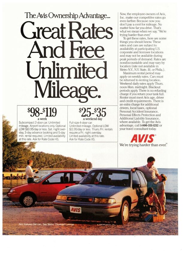
Per this 1991 Avis ad (hard to find), the pricing for the Toronado was not outlandish as a Geo Metro was up to $119 ($272 adj.) a week in that year. But if pricing wasn’t the barrier, what was? It seemed to fall into two categories: data limitations, and the government. We’ll pick up there in Part IV.
[Images: GM, YouTube]
Become a TTAC insider. Get the latest news, features, TTAC takes, and everything else that gets to the truth about cars first by subscribing to our newsletter.